
BLM Fire Risk Reduction Project - 2026 Update
Owyhee Irrigation District (OID), in partnership with the U.S. Wildland Fire Service and with support from the Bureau of Land Management (BLM), is implementing a multi‑year wildfire risk reduction project across Malheur County. This effort is designed to reduce wildfire hazards in the wildland‑urban interface while strengthening emergency response capabilities and protecting critical infrastructure.
The project is funded through a BLM Wildfire Community Assistance grant awarded in 2024. Combined with local matching funds from OID, the initiative represents more than $1.3 million in investment over five years, with work continuing through fall 2029.
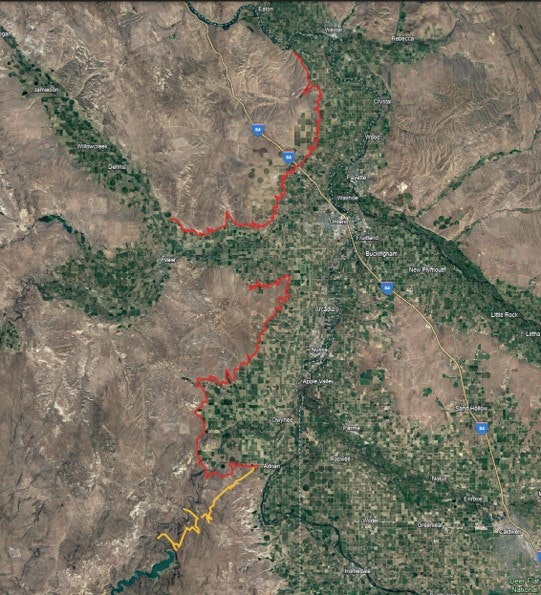
Project Area
Work is being carried out throughout OID’s service area, from Adrian north to the Snake River, including areas near Ontario, Lake Owyhee, and key utility and transportation corridors. Many of these areas have experienced significant wildfire activity in the past, including overlapping with the footprint of the 2025 Mendiola Fire.
What the Project Includes
The wildfire mitigation effort focuses on proactive, on‑the‑ground improvements, including:
-
Fuel Break Development
Repairing and reclaiming canal maintenance roads and key desert access roads to serve as fuel breaks between wildlands, agricultural land, and residential areas. -
Emergency Access Improvements
Restoring and strengthening access routes to improve response times and reliability for wildfire suppression crews. -
Water Access for Firefighting
Enhancing access to canal water supply locations so fire apparatus can safely and quickly refill during suppression efforts. -
Vegetation Management
Mowing and applying approved herbicide treatments to reduce invasive annual grasses and noxious weeds that contribute to wildfire spread, while supporting favorable growth of native species. -
Community Fire Prevention Outreach
Engaging local water users, landowners, and residents with information on safe practices and actions they can take to reduce wildfire risk on their property.
Progress to Date
Work completed during 2025 includes:
- 350 acres of mowing
- Vegetation management on BLM, Bureau of Reclamation, Oregon state, and private lands
- Rehabilitation of 19.5 miles of backcountry access road, including installation of culverts in eroded drainage areas
- Restoration of six water supply access locations critical for firefighting operations
Why This Matters
OID’s canal system creates a unique opportunity to maintain wide, continuous fuel breaks at the transition zone between wildlands and communities. By restoring and maintaining these corridors, the district can help slow or stop the spread of wildfires, protect homes and agricultural assets, and support safer, more effective fire suppression operations.
The project aligns with the National Cohesive Wildfire Strategy and national wildfire prevention priorities, emphasizing collaboration, risk reduction, and community resilience.
Partnerships
This project is made possible through cooperation between:
- Owyhee Irrigation District
- Bureau of Land Management
- U.S. Wildland Fire Service
- Local landowners and water users